To teach my preschooler how to read a map, I took a suggestion from Help Your Preschooler Build a Better Brain*, and I had him first construct maps, before reading them. (*Hands down the best book for toddler and preschooler activities I have read as of yet.)
Constructing a Map
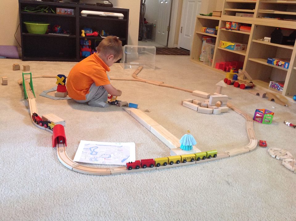
My son loves to build train tracks, with wooden tracks that we got from Ikea. We also are so lucky to live in central Florida, and we often visit the Walt Disney World theme parks. My son loves the train at Magic Kingdom. It was a miraculously perfect fit to have him build the train tracks at Magic Kingdom, from a map, as our first construct a map activity
When my son was 2 years, 10 months, I sat down with him to build our first “Magic Kingdom train tracks.” It was a pretty big hit. On our first try at it, he took a tunnel and put it correctly on the tracks where one of the actual tunnels is. For the next 3 days, all day, we built “Magic Kingdom train tracks.” They became very high fidelity. He liked to build a long walkways from the train station to the castle, which he built out of blocks. We had blue construction paper for the river; a windmill on Tom Sawyer Island; a tea cup for the tea cup ride; Dumbo for the Dumbo ride; blocks for the Speedway race track; magnetic squares put together for Space Mountain; and more. But one picture of one of our Magic Kingdom train track building days:
At first I thought I gave him too much, too soon, because he kept asking me to do this activity–but he wanted me to set almost the whole thing up. I did this with him, indeed, for a few days, but then I told him he needed to do it. My barometer for if something is a good activity is if he does it, on his own. If not, it’s too much. It’s hard to know sometimes what is the line between a “strong demonstration,” such that he gets it, versus doing the whole thing for him, an indication that an activity that is too much. So, after a few days, I did stop. Unfortunately, at first, he not only did not do Magic Kingdom train tracks, but no train tracks at all … Until about 2 or 3 months later, when he found the map again, and, on his own, put the Magic Kingdom train tracks together! The tracks are not that complicated–just a loop, somewhat in the shape of a square, and he did it! Indeed, in looking through photos, about that time is when he started to also make train tracks that looped back onto themselves.
When we went to Magic Kingdom and went on the train, of course I brought the map. I tried to discipline myself to not point things out to him as we went around, so he could notice what things were, and how they were the same as on the map. The very first ride produced no noticeable observations. I have noticed that almost all activities require exposure, then one night’s sleep, then the skill starts to noticeably develop. It was the next train rides, in days after, that he started to notice what was what. Although it’s been about 4 months since we’ve been to Magic Kingdom, my son can still tell you that there are 3 train stations; that there is a bridge that goes over the river; where “animals” are on the ride; and more. All of this helped him build an unbelievable memory of all of that.
Google Maps
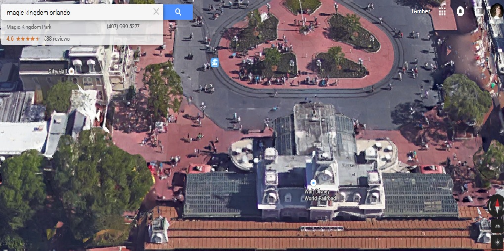
Another great activity is to take advantage of Google maps. Just recently I did this with him (3 years, 4 months) again, and he requested we look at “Big ball” (Epcot) and Magic Kingdom. Using Google maps, I pretended to walk through the entrance of Magic Kingdom, then up to the train (and said my son, happily, “And we would have to wait for the train to come!” “Here it comes! Choo choo! Clang Clang!”), then around the loop of the train tracks. After this, he said, “Now lets go on another ride.” It’s as if we were there.
We also used Google Maps to look at our neighborhood. Nothing teaches a person how to get around a place quite like walking or driving it (while in the driver’s seat). After we went for a walk, where he rode his tricycle, I called up Google maps. We went over the path we took. I peppered him with a few questions, such as what the road names were and what buildings were, and he answered them correctly. A few weeks ago when we did a similar thing with a printed map, he pointed to our community center and said “17794.” I looked it up: it is the address of the community center. (My mouth dropped …. )
Google Maps is a great app to have on an iPad that your child has access to. It is stunning visually and easy to navigate, at the end of your fingertip. I plan on using it the next time I go anywhere new. (These map activities have really helped me learn navigational skills better.) My son now knows words/phrases like “zoom in,” “zoom out,” and “paint.” When he learns to read, I hope he will call it up and type in whatever city or place he wants to learn about and explore away.
Printing Maps
One of the best activities I did was to print a map to a place we go often: Gymnastics. It’s about a 20 minute drive. At first I drew a map, with him, and exaggerated some of the streets, such that they were not to scale. I put markers on the map for him. I had a “1” for the first stop sign “2” for the second one and “3” for the third one. I wrote the names of the streets for him. I drew a pyramid by gymnastics because one of the buildings had a pyramid outside. He then held the map as we drove. I would tell him we were at the first stop sign, etc. He can also identify the first letter of the road, so he would find street names based on this. He often tried to read street signs–unfortunately I usually couldn’t stop long enough as he spelled out the words!
I was pretty surprised by how he attacked this problem of knowing the path we took and the names of roads: With each new road, he asked me “Mommy what was the first road we were on?” (Emphasis mine) So, I would say it, which is the road we live on. Then he asked, “What’s next?” So it kept going like that with every new road: He wanted to go back to the first road and then know what was next, next, and next, up to the road we were currently on. This is a lot like counting, where it is best to count, using rods, starting over with each new one, “This is 1. This is 1, 2. This is 1, 2, 3.”
Navigating the roads taught a lot about road signs, too. I pointed out some signs that were arrows, which warned us about sharp bends up ahead. He is very familiar with sharp bends, because he does build train tracks so often. He loves looking for those signs. I also point out to him how I apply a force to turn into the curve, which is a centripetal force, and then he feels like he is going outwards, a centrifugal force. 😉
Finding the “X” on the ground
To get my son reading a map and using it to find things, I did an activity where I painted or chalked an “X” on the ground or grass then marked a printed map with where the “X” was, and then had him find it. I first started by printing out a map of our backyard (from Google Maps.) I painted an “X” on the grass just outside our patio. I drew an “X” on the map that I printed. I told him I had a fun game planned to go find an X in the backyard. He was very excited! He found it easily–that was the point.
I then drew an “X” in our backyard further and further away from the patio and drew the X on a printed map. He found them easily–going right to them, based on where the “X” was on the printed map. We used the printed map to see (and go touch) where our 2 trees were, where the corners of our fence were, etc. I also reversed the activity where I had him pick a place on the grass to paint an “X,” then I asked him where on the map I should draw the X. All of this was super easy for him, but it gave him confidence in his ability to find the “X” for more difficult challenges.
I then printed a map of our block. I drew an “X” with chalk on the sidewalk, not far from our driveway, on the path we normally take when we go for a walk. He almost couldn’t help but “stumble” right on it. I plan on drawing “X”s further and further away from our house, as a continuing activity. Friday nights are a nice time for us to do it, because dad is home, and we go for a family walk. I go draw the X, then draw it on the map, then we go find it.
I like this activity because the activity stresses another important skill: Literally not just taking the same old beaten path. We normally take the same path for a walk every time we go. To find the “X,” he has to actively choose to do something different from normal, based on his mind, based on the “X” I draw for him on the maps. These navigational skills go a long way towards teaching a child to navigating their own life–to not just follow everyone else. How many times have you seen drivers on the road, huddled in a lane, all trying to get off at the same exit, when some simple navigational and reading skills could have told them the next exit would also get them to where they want to go? This is not just a navigational skill; this is a character trait that is getting practice.
When my son can find an “X” significantly far away from our house and in a place that is not our normal path–this is when I will consider him to be able to read a map
A Magnetic Compass
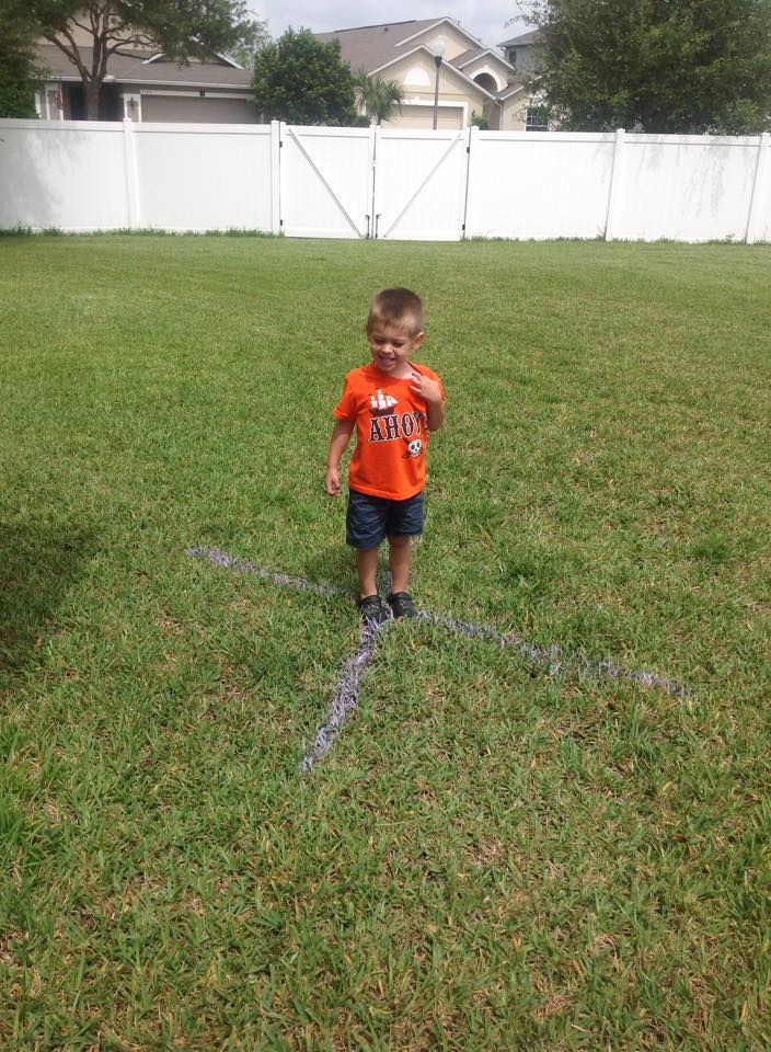
In Montessori, the children feel lessons–they learn by actively doing or feeling something. To learn “verbs” for instance, the child jumps up and down, runs, etc., being told those are all verbs. For an introduction to a magnetic compass, I asked him to pick a spot in our backyard to place it. I then spray painted lines in all 4 directions: North, South, West, East. He then, almost on his own, started following the lines. We did many games where he walked north, south, west, and east. I stressed that the red arrow on our compass always pointed north. This cemented this idea much better than had I just tried to explain it verbally.
This activity should be done more than once. This is because, first, most activities, I have found, are best if they are presented twice, on separate days. But, more, the child needs to get the idea that North is not just a particular point on the ground to another, but a general direction that can be found from standing anywhere. I am finding a magnetic compass works best when completely still, i.e., not while driving in a car. I plan on occasionally bringing a magnetic compass with us on walks, as well as chalk, and drawing which way is North, South, West, East. We can bring it with us on other trips too, to again find North, South, West, East.
Another activity I have in mind is to also bring a map of the places that we go to, draw the N-S-W-E compass on the map, and align it with the magnetic compass on the ground. He can then see how the map is then oriented to where we are standing.
*A note on these activities and a look to the future*
Montessori noticed that very simple activities that draw a child’s attention to some part of reality or teach a simple skill cause children to become observers of the world. These very simple map activities have raised my son’s awareness about many navigational related things. He asks questions about them often. He frequently asks what road we are on. He asks what the road we are on is going to take us to (what the next road will be.) He tries to read road signs. He loves “STOP” signs. When on his tricycle, he always stops at them. Lately he has been asking which way is north, south, west, and east.
In Montessori, the child uses wooden puzzles such that geographical areas are broken up into a puzzle, such as the whole world into continents, or countries in a continent, or the states in the United States. This is a great activity and I look forward to it. However, I have seen children as young as 2 working on something like this. If a child doesn’t know what a “state” is or what a “map” is, I am not sure they will get the intellectual benefit out of these puzzles. I think the above map work will give a great foundation for these great puzzles, which I do plan on starting soon.
I am certainly looking forward to when we have the opportunity to look at completely new maps for him to look at, digest, and use. Zoos provide the easiest practice: they are often just a loop with spokes that radiate from the loop. Any kind of amusement park map is pretty kid friendly as first map practice.
Terrain map, latitude/longitude, etc. will all come in time …